Introduction
In six Madhya Pradesh towns, most households depend on septic tanks or soak pits, many of which fail during the monsoon as groundwater rises and percolation drops. Natural drainage, slope and monsoon runoff expose dense cores and low-lying settlements to flooding, and narrow access in these areas limits desludging. The towns, Sanchi, Khajuraho, Maihar, Nagda, Dhamnod and Rajnagar, range from heritage centres with large seasonal tourist inflows to agrarian and industrial settlements.
Project info
- Client: Government of Madhya Pradesh
- Period: 2021 – 2023
- Location: Sanchi, Khajuraho, Maihar, Nagda, Dhamnod and Rajnagar, Madhya Pradesh, India
Scope
The project evaluated and strengthened the sanitation systems of the six towns through citywide inclusive sanitation (CWIS) strategies. The scope covered containment practices, desludging operations, treatment system upgrades, greywater management needs, technology options and financially phased implementation pathways.
Geospatial analytics, hazard mapping, sanitation service diagnostics and water-sensitive approaches were brought together in a single CWIS framework. The work focused on wastewater management, flood-linked vulnerabilities, operational constraints in dense settlements, and long-term regulatory and financial planning for climate-resilient sanitation in every town.
Did You Know?
- These towns host globally renowned heritage sites such as Sanchi Stupa and Khajuraho Temples, attracting large seasonal tourist inflow that places additional pressure on sanitation systems.
- Several towns exhibit high dependency on on-site sanitation systems, with significant shares of households relying on ageing septic tanks and soak-pits.
Services Delivered
Geospatial Assessment
A consolidated geospatial assessment used GIS mapping, thematic layers and terrain–hydrology analysis to understand sanitation gaps, settlement expansion and environmental sensitivities, and to identify risk hotspots that shaped the CWIS strategies.
Flood Modelling and Risk Mitigation
Flood-prone and waterlogged zones in each town were assessed using elevation, slope, drainage density and land use. The results guided targeted mitigation and the placement of sanitation interventions to protect containment systems.
Wastewater Management
Existing containment and collection systems were assessed, and wastewater management solutions were proposed, including treatment upgrades, decentralised systems where needed and improved greywater pathways suited to local conditions.
Greywater Management as Pilot Solutions
Greywater zones were delineated from watershed boundaries, density patterns and built form. High-density areas with poor drainage or failing soak pits were prioritised for decentralised conveyance and treatment pilots.
Cost Estimates and Phased Plans
Financially feasible, phased investment plans were prepared so that each town could move to a resilient sanitation pathway in manageable steps.
Regulatory Reform Recommendations
Policy guidance was developed to strengthen desludging operations, improve compliance, adopt context-appropriate technologies and prepare institutions for CWIS implementation.
Results
- Climate-resilient CWIS plans prepared for six towns: Sanchi, Khajuraho, Maihar, Nagda, Dhamnod and Rajnagar.
- Flood and waterlogging risk zones mapped in each town and used to site sanitation interventions.
- Greywater zones delineated, with high-density, poorly drained areas prioritised for decentralised pilots.
- Phased investment plans and regulatory recommendations handed over for each town.
Work Illustration
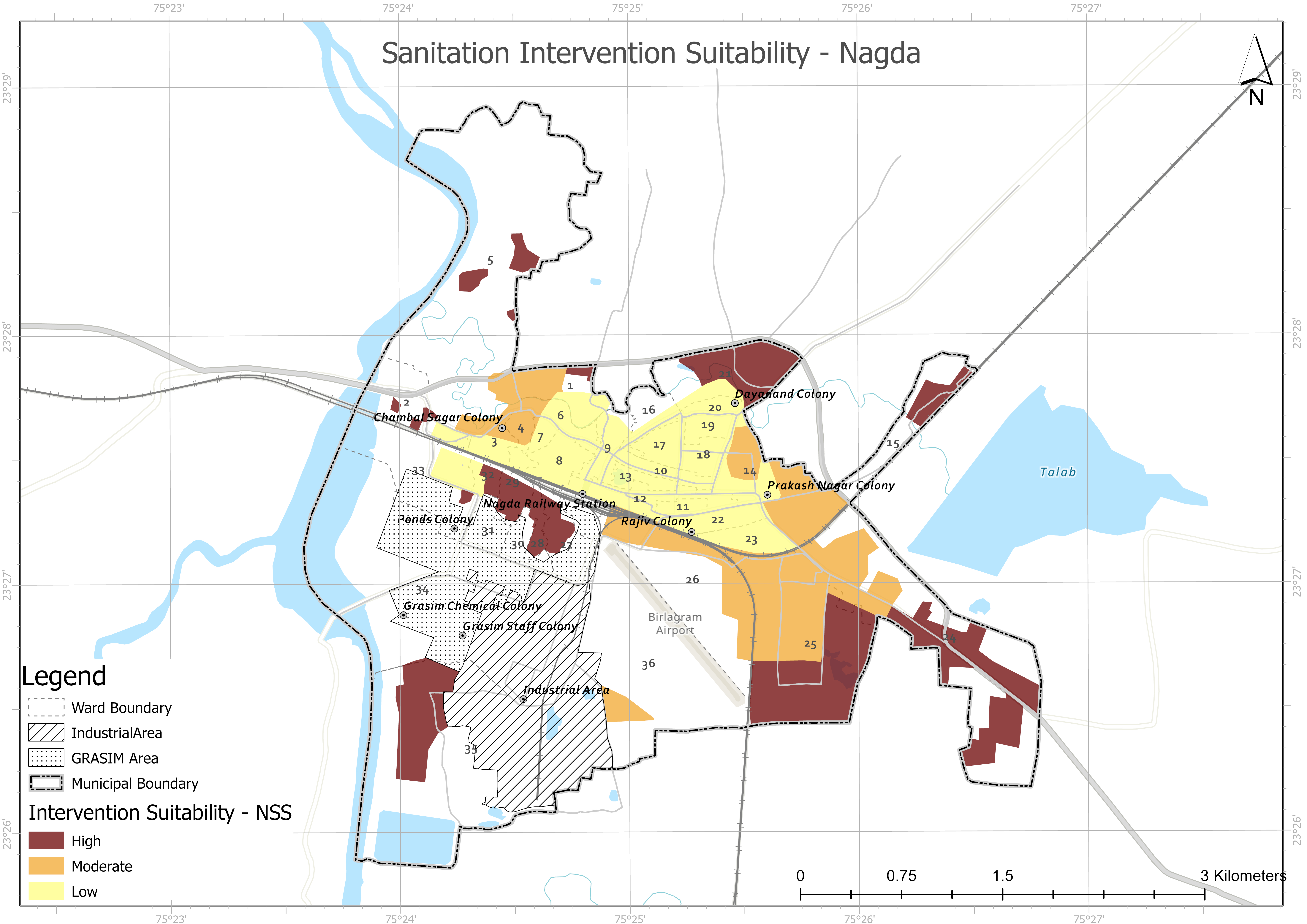
Across the six towns, terrain and hydrology parameters such as elevation, slope, drainage density and land cover shape monsoon runoff. Vulnerable pockets, typically dense cores, low-lying areas and settlements close to natural drains, experience more waterlogging and flood exposure.
These areas also coincide with sanitation service problems, including toilet backflow, non-functional soak pits, leachate discharge into drains and limited desludging access. Together, settlement form, drainage behaviour and containment performance show why CWIS planning has to target high-risk clusters and build resilience across all six towns.